Unveiling South America’s Green Canvas: The Ultimate Vegetation Map Guide
From the steamy depths of the Amazon to the windswept plateaus of Patagonia, South America is a continent of breathtaking botanical extremes. This guide will take you on a journey across its vast green canvas, decoding the complex vegetation map that defines this land. You’ll discover the major biomes, understand the forces that shape them, and learn how to read the patterns of life that cover the continent from the Caribbean coast to the icy tip of Tierra del Fuego.
The Amazon Rainforest: The Lungs of the Earth
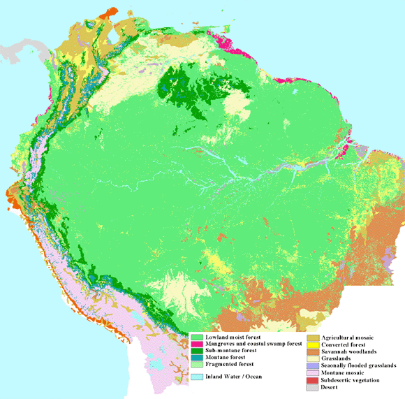
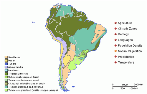
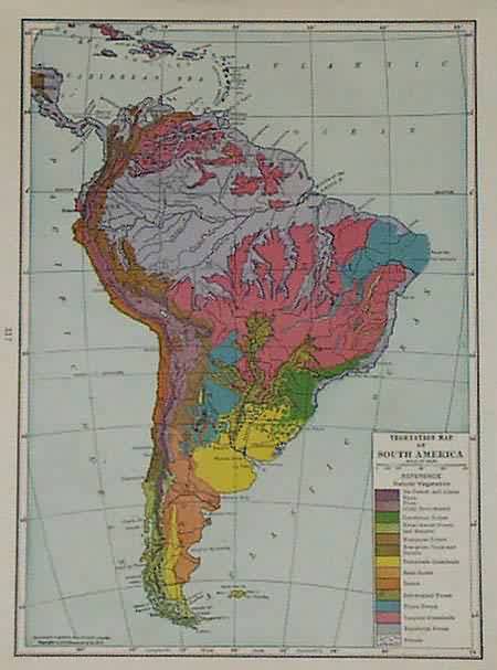
Covering an area larger than the continental United States, the Amazon rainforest dominates the northern half of South America. This is not a uniform green blob but a mosaic of flooded forests (várzea), terra firme (upland forests), and igapó (blackwater forests). The vegetation map here shows a dense, evergreen canopy that supports more species of plants and animals than anywhere else on Earth. The key factor is relentless humidity—the Amazon receives over 2,000 mm of rain annually, with no true dry season. The trees are tall, buttressed, and layered, creating a complex vertical structure that traps moisture and sustains a biodiversity powerhouse.
The Andes: Vertical Zonation of Life
As the vegetation map climbs the Andes, the world changes dramatically. This mountain range creates a series of life zones based on altitude. At the base of the eastern slopes, you find cloud forests—mossy, mist-shrouded woodlands packed with epiphytes like orchids and bromeliads. Climb higher, and you enter the puna and páramo: high-altitude grasslands that are the floral equivalent of alpine tundra. Here, hardy plants like the giant rosette-forming frailejones adapt to intense UV radiation and freezing nights. On the western, rain-shadowed side of the Andes, the map turns stark: the Atacama Desert, one of the driest places on Earth, supports almost no vegetation except for rare lomas formations where coastal fog condenses.
The Cerrado and Caatinga: Brazil’s Dry Heart
East and south of the Amazon, the vegetation map shifts into a patchwork of savannas and dry woodlands. The Cerrado, a vast tropical savanna covering over 20% of Brazil, is not a single habitat but a gradient: from grassy fields to scrubby, twisted trees with thick bark and deep roots. Fire is a natural part of this ecosystem, and many plants have evolved to resprout after burning. Further northeast lies the Caatinga, a unique dry forest of thorny bushes and cactus adapted to long, severe droughts. When rains finally come, the landscape explodes into a brief, vivid green—a survival strategy written into the DNA of every plant.
The Pantanal: The World’s Largest Wetland
In the heart of the continent, the Pantanal floods seasonally, creating a dynamic vegetation pattern that cycles between aquatic and terrestrial phases. The map here shows a mosaic of flooded grasslands, gallery forests along rivers, and shrublands on slightly higher ground. During the wet season, water spreads across the flat basin, and floating plants like water hyacinths dominate. As the water recedes, lush pasture emerges, attracting massive herds of capybara and caiman. The Pantanal’s vegetation is uniquely resilient to these dramatic swings, with many trees developing buttressed roots and hollow trunks to survive months of immersion.
The Gran Chaco and Patagonian Steppe
Descending south from Brazil, the vegetation map enters the Gran Chaco, a hot, semi-arid region of thorn forests and scrubland that spans Bolivia, Paraguay, and Argentina. This is a land of spiny acacias and quebracho trees, whose hard, dense wood is prized for its tannins. Further south, the Patagonian steppe stretches across the Argentinean and Chilean pampas. Here, the map turns pale brown and gray—a cold, wind-swept desert of tussock grasses, dwarf shrubs, and lichens. Rainfall is scarce, and the constant wind creates a unique biome where plants grow low and tough, forming cushions or creeping mats to survive the brutal conditions.

Coastal and Mangrove Vegetation
Along South America’s extensive coastlines, the vegetation map highlights critical ecosystems: mangroves and restingas. Mangrove forests line tidal estuaries from Venezuela to Brazil, with species like red, black, and white mangroves adapted to saltwater, low oxygen, and shifting sediment. Their tangled roots act as nurseries for fish and stabilize the shoreline. On sandy coastal plains, the restinga forms a scrubby, wind-pruned forest of salt-tolerant plants, palms, and cacti. These coastal strips are vulnerable to development but are vital buffers against storm surges and erosion.
Conclusion
South America’s vegetation map is not just a static chart; it is a living, breathing document of adaptation and survival. From the humid giants of the Amazon to the frost-hardy cushions of the Patagonian steppe, each region tells a story of climate, geography, and evolutionary ingenuity. Understanding this mosaic reveals why South America is a cradle of biodiversity—and why its preservation is critical for the health of our entire planet. Whether you are a botanist, a traveler, or simply a lover of nature, the green patterns of this continent offer endless wonder and a powerful reminder of the web of life that sustains us all.
1968 Map Showing Vegetation In South America

1968 Map Showing Vegetation in South America
(PDF) A Vegetation Map Of South America

(PDF) A vegetation map of South America
Vegetation Map For South America Projected For Different Holocene

Vegetation map for South America projected for different Holocene ...
Map Of Southern South America Showing Vegetation Zones Based On Refs

Map of southern South America showing vegetation zones based on refs ...
Forest Observations
Forest Observations
Forests In South America Map

Forests In South America Map
(a) Map Of Major Vegetation Types In Central And Northern South America

(a) Map of major vegetation types in central and northern South America ...
[PDF] Vegetation Map Of South America; Explanatory Notes By UNESCO
![[PDF] Vegetation map of South America; explanatory notes by UNESCO](https://img.perlego.com/books/RM_Books/unesco_mthlljsk/9789230019334_300_450.webp)
[PDF] Vegetation map of South America; explanatory notes by UNESCO ...
(PDF) A DIGITAL VERSION OF HUECK'S VEGETATION MAP OF SOUTH AMERICA: 50

(PDF) A DIGITAL VERSION OF HUECK'S VEGETATION MAP OF SOUTH AMERICA: 50 ...
Vegetation Map Of South America From AVHRR 1992/1993. Available At

Vegetation map of South America from AVHRR 1992/1993. Available at ...
Figure 7 - A Vegetation Map Of South America
Figure 7 - A vegetation map of South America
(a) Map Of Major Vegetation Types In Central And Northern South America

(a) Map of major vegetation types in central and northern South America ...
South America Vegetation - Full Size

South America vegetation - Full size
Vegetation Map Of South America From AVHRR 1992/1993. Available At

Vegetation map of South America from AVHRR 1992/1993. Available at ...
Vegetation Quotes. QuotesGram
Vegetation Quotes. QuotesGram
Vegetation South American Deserts Arid Landscape Of Atacama Desert
Vegetation South American Deserts Arid Landscape Of Atacama Desert
(PDF) A Vegetation Map Of South America

(PDF) A vegetation map of South America
Map Of Southern South America Showing Major Vegetation Types (after
Map of southern South America showing major vegetation types (after ...
Vegetation Map Of South America | PDF | Grassland | Forests

Vegetation Map of South America | PDF | Grassland | Forests
1941 MAP ~ SOUTH AMERICA ~ VEGETATION FOREST PAMPAS GRASS TROPICAL | EBay

1941 MAP ~ SOUTH AMERICA ~ VEGETATION FOREST PAMPAS GRASS TROPICAL | eBay
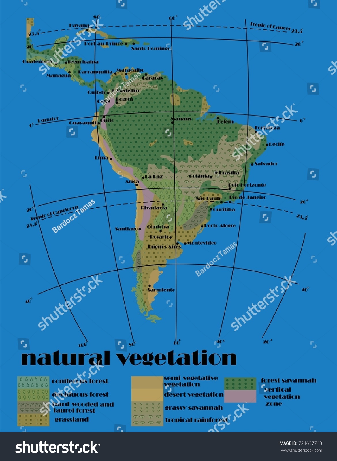
Vegetation Map America A VEGETATION MAP OF SOUTH AMERICA

Vegetation Map America A VEGETATION MAP OF SOUTH AMERICA
Map Of Southern South America Showing The CWP, Main Vegetation

Map of Southern South America showing the CWP, main vegetation ...
Map Of South America

Map Of South America
Vegetation Map South America - Art Source International
Vegetation Map South America - Art Source International
Figure 2 - Vegetation Map Of South America
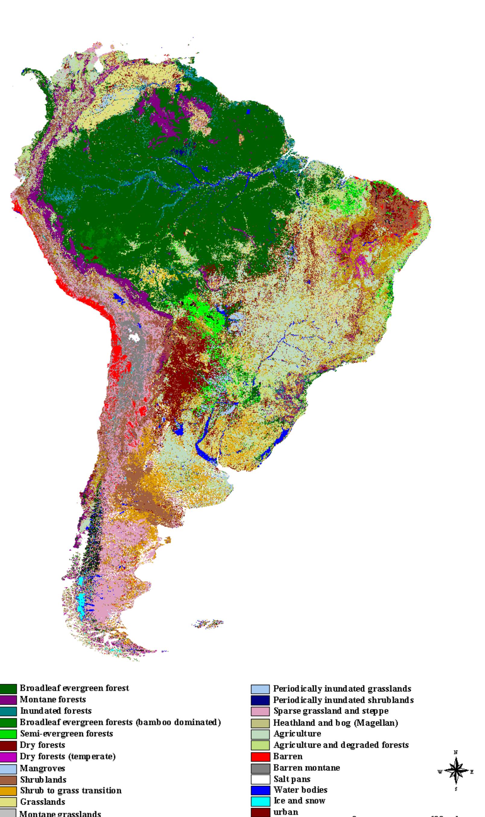
Figure 2 - Vegetation Map of South America
Figure 3 - Vegetation Map Of South America
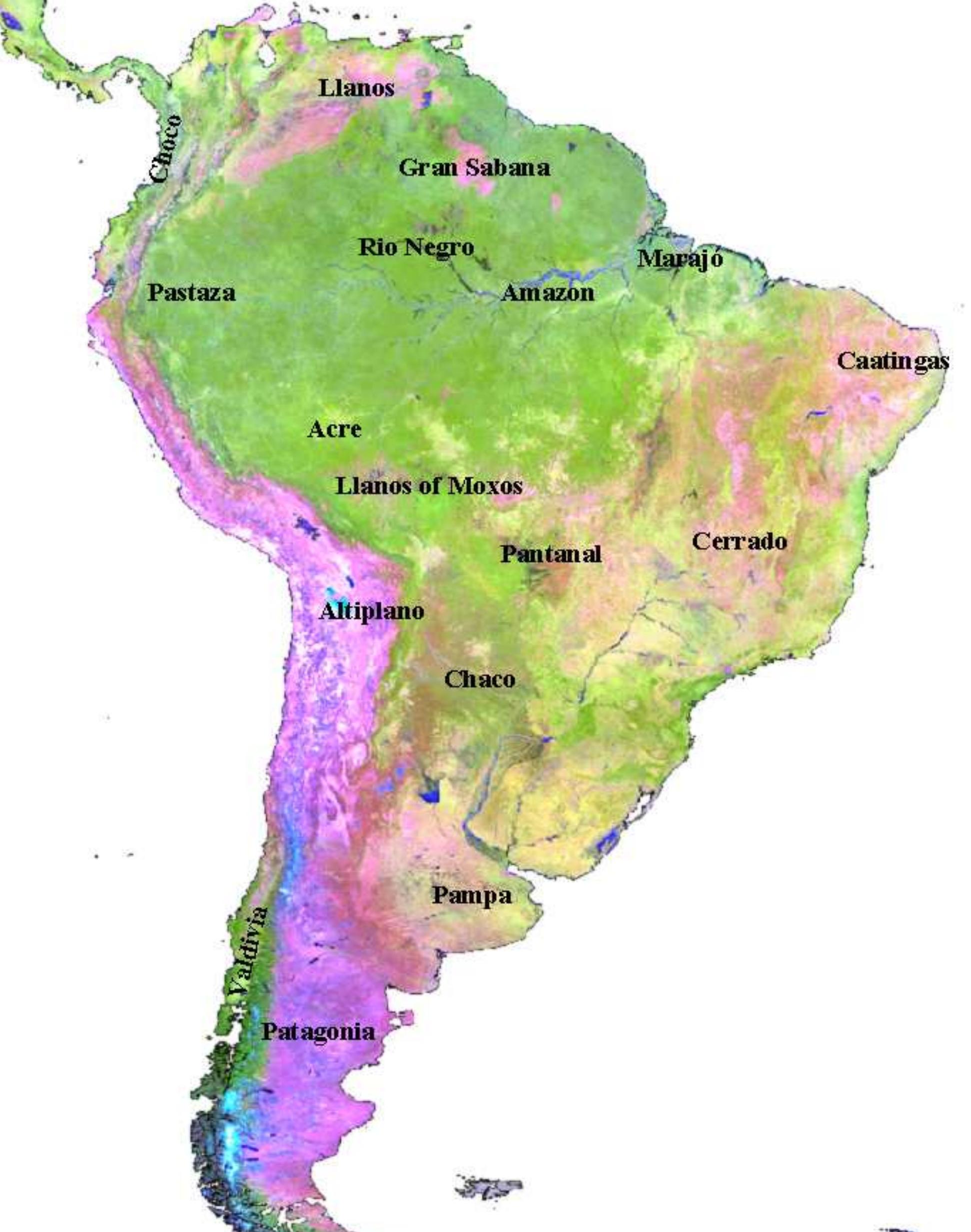
Figure 3 - Vegetation Map of South America
(PDF) A Map Of Vegetation Of South America Based On Satellite Imagery

(PDF) A Map of Vegetation of South America Based on Satellite Imagery
Forests In South America Map

Forests In South America Map
(PDF) A Vegetation Map Of South America

(PDF) A vegetation map of South America
Map Situating The 26 Vegetational Units In South America. | Download

map situating the 26 vegetational units in South America. | Download ...
South America's Vegetation And Constraints

South America's Vegetation and Constraints
4. Vegetation Map Of Temperate Southern South America. | Download

4. Vegetation map of temperate southern South America. | Download ...
(a) Map Of Major Vegetation Types In Central And Northern South America

(a) Map of major vegetation types in central and northern South America ...