Exploring the Diverse Vegetation Zones of South America: From Lush Amazon to Arid Patagonia
Welcome, fellow nature enthusiast! South America is a continent of staggering ecological contrasts, and understanding its vegetation zones is like unlocking a secret map of life. In this guide, you'll journey from the steamy, oxygen-rich Amazon rainforest to the bone-dry Atacama Desert, and from the windswept Patagonian steppe to the misty heights of the Andes. We'll explore each distinct zone together—what grows there, why it grows there, and how these regions shape the continent's identity. By the end, you'll see South America not just as a place on a map, but as a living, breathing mosaic of green and brown.
The Amazon Rainforest: The Lungs of the Planet
Let's start where the green is so dense it feels like a forest that never ends. The Amazon rainforest is the world's largest tropical rainforest, covering much of northern Brazil, Peru, Colombia, and several other countries. It's a hyper-diverse zone where rain falls year-round—over 2,000 millimeters annually. The vegetation here is stratified into layers: the emergent layer (towering trees like kapok), the canopy (a thick blanket of leaves), the understory (filtered light, ferns, and shrubs), and the forest floor (dark, decomposing leaves and fungi). Iconic plants include Brazil nut trees, rubber trees, and countless orchids. This zone is crucial for global climate regulation, but it's also under constant threat from deforestation. When you picture the Amazon, think of a sprawling, living cathedral of biodiversity.

The Cerrado: Brazil's Savanna Giant
Head slightly south or east of the Amazon, and you enter the Cerrado, a vast tropical savanna that covers about a fifth of Brazil. Many folks mistake it for a "lesser" ecosystem, but that's a mistake. The Cerrado has its own unique charm: twisted trees with thick bark to survive fires, deep roots to tap groundwater during dry seasons, and a spectacular array of flowering plants like the pequi tree and various bromeliads. The landscape shifts between open grasslands, scrubby woodlands, and gallery forests along rivers. It's a fire-adapted zone, where dry winters (May to September) create conditions for natural blazes that many plants actually need to germinate. If the Amazon is a wet sponge, the Cerrado is a resilient, sun-baked tinderbox full of life.
The Pantanal: The World's Largest Wetland
Now, let's get our feet wet—literally. The Pantanal, mostly in western Brazil but spilling into Bolivia and Paraguay, is a massive floodplain that transitions between wet and dry seasons. During the rains (October to March), it becomes an inland sea, with water levels rising up to 5 meters. The vegetation here is a mix of flood-tolerant grasses, water hyacinths, and deciduous trees that can survive drowning. In the dry season, the landscape opens up, and wildlife flocks to the remaining waterholes. This zone isn't as famous as the Amazon, but it's arguably more accessible for seeing jaguars, capybaras, and giant river otters. The plants here are masters of adaptation—some even have air pockets in their stems to keep oxygen flowing when submerged.
The Gran Chaco: The Thorny Wilderness
Further south and west, you'll encounter the Gran Chaco, a hot, semi-arid region stretching across Paraguay, Bolivia, and northern Argentina. This is a harsh place: temperatures can soar past 45°C, and rainfall is erratic and seasonal. The vegetation reflects that toughness. You'll find vast stretches of thorny shrubs, cacti, and hardwood trees like quebracho (whose name literally means "break the axe"). Many plants have tiny leaves, spines, or waxy coatings to reduce water loss. The Chaco is also home to the world's largest rodent, the capybara, though they stick to the few rivers that cut through this dry land. It's a zone that rewards patience—look closely, and you'll see vibrant bromeliads clinging to tree branches, soaking up every drop of humidity.
The Atacama and Peruvian Deserts: Life at the Extremes
On the western coast of South America, running through Chile and Peru, lies the Atacama, the driest non-polar desert on Earth. Some parts haven't seen rain in centuries. Yet, vegetation finds a way. In the lomas formations—coastal hills where fog rolls in from the Pacific—you'll find ephemeral "fog oases" with cacti, lichens, and flowering herbs that bloom only during rare mist events. The Peruvian desert is slightly less extreme, with scattered algarrobo trees and hardy grasses. This zone teaches you a profound lesson about life: it doesn't need much to survive, just a sliver of opportunity. The famous "flowering desert" phenomenon (desierto florido) occurs every few years when unusual rains transform the barren landscape into a carpet of pink, yellow, and purple blooms.
The Andes: Life in the Vertical Gradient
Now, we ascend the Andes, the spine of South America. This mountain range creates a vertical zonation of ecosystems from the base to the snowy peaks. Starting at the lower slopes, you find tropical montane forests (yungas) filled with ferns, mosses, and orchids. Climb higher, and you reach the puna—a high-altitude grassland with tough, clumping grasses like ichu and hardy cushion plants. Above 4,500 meters, the vegetation thins to only a few species, like the giant rosettes of the Puya raimondi, which can live for over a century before blooming once and dying. The altiplano (high plateau) in Bolivia and Peru features salt flats and sparse, salt-tolerant shrubs. Every 1,000 feet you climb changes the plant community completely—a living lesson in ecology.
The Pampas: Grasses That Stretch to the Horizon
Drop down from the Andes to the east-central lowlands of Argentina, Uruguay, and southern Brazil, and you enter the Pampas. This is the breadbasket of South America—a vast, flat grassland with deep, fertile soils. The natural vegetation is dominated by perennial grasses like Stipa and Paspalum, with few trees except along riverbanks. Fires and grazing by native herbivores (like the rhea and pampas deer) once maintained this open landscape. Today, much of it has been converted to soybean and corn fields, but in protected areas, you can still see the original sea of grass rippling in the wind. The Pampas feel endless, and they remind you that grasslands are just as important as rainforests in the continent's ecological dance.
Patagonian Steppe and Magellanic Forests: The Cold South
Finally, we travel to the southern tip of the continent. Patagonia, shared by Argentina and Chile, is a land of extremes: intense winds, cool temperatures, and low rainfall. The vegetation here is the Patagonian steppe—a dry, shrubby grassland with tough plants like bunch grasses, tussocks, and the spiny calafate berry bush. But along the coast and in the rain shadow of the Andes, you find the Magellanic subpolar forests, dominated by lenga beech, ñire, and the ancient monkey puzzle tree (Araucaria araucana). These forests are wet, mossy, and otherworldly, often shrouded in mist. It's a fitting, dramatic end to our journey—a reminder that even at the edge of the world, life finds a way to cling to the rocks and wind.
Conclusion
From the dense, humid Amazon to the windswept Patagonian steppe, South America's vegetation zones are a testament to the planet's ability to create life under every condition imaginable. Each zone tells a story of water, fire, altitude, and adaptation. Understanding them helps us appreciate not just the continent's natural beauty, but also the fragile balance that sustains it. Whether you're a traveler, a student, or just a curious soul, I hope this guide has given you a richer sense of the green (and brown and gray) tapestry that makes South America so unforgettable. Next time you look at a map, let the vegetation zones guide your imagination.
South America - Plant Hardiness Zone - A Gardeners Forum
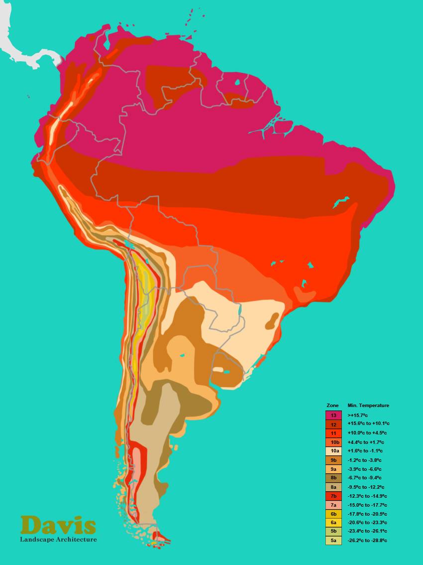
South America - Plant Hardiness Zone - A Gardeners Forum
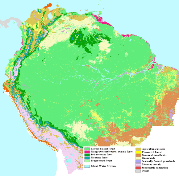
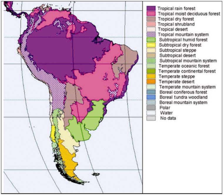
Vegetation Map Of South America From AVHRR 1992/1993. Available At

Vegetation map of South America from AVHRR 1992/1993. Available at ...
Climate Zones South America At Lara Roberts Blog

Climate Zones South America at Lara Roberts blog
(a) Map Of Major Vegetation Types In Central And Northern South America

(a) Map of major vegetation types in central and northern South America ...
Vegetation Map America A VEGETATION MAP OF SOUTH AMERICA

Vegetation Map America A VEGETATION MAP OF SOUTH AMERICA
Vegetation Map Of South America | PDF | Grassland | Forests

Vegetation Map of South America | PDF | Grassland | Forests
Major Vegetation Zones Of Southern South America. | Download Scientific

Major vegetation zones of southern South America. | Download Scientific ...
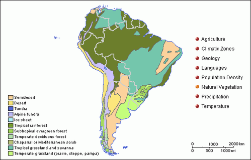
South America's Vegetation And Constraints

South America's Vegetation and Constraints
South America Vegetation - Full Size

South America vegetation - Full size
Make Map South America Biomes Different AI-generated Image 2331278817

Make Map South America Biomes Different AI-generated image 2331278817 ...
(PDF) A Vegetation Map Of South America

(PDF) A vegetation map of South America
Vegetation Map For South America Projected For Different Holocene

Vegetation map for South America projected for different Holocene ...
Tropical Forests In South America Incredible Rainforests Of South

Tropical Forests In South America Incredible Rainforests Of South
Vegetation South American Deserts Arid Landscape Of Atacama Desert
Vegetation South American Deserts Arid Landscape Of Atacama Desert
Figure 7 - A Vegetation Map Of South America

Figure 7 - A vegetation map of South America
Map Situating The 26 Vegetational Units In South America. | Download

map situating the 26 vegetational units in South America. | Download ...
South America Natural Vegetation Stock Vector (Royalty Free) 724637743
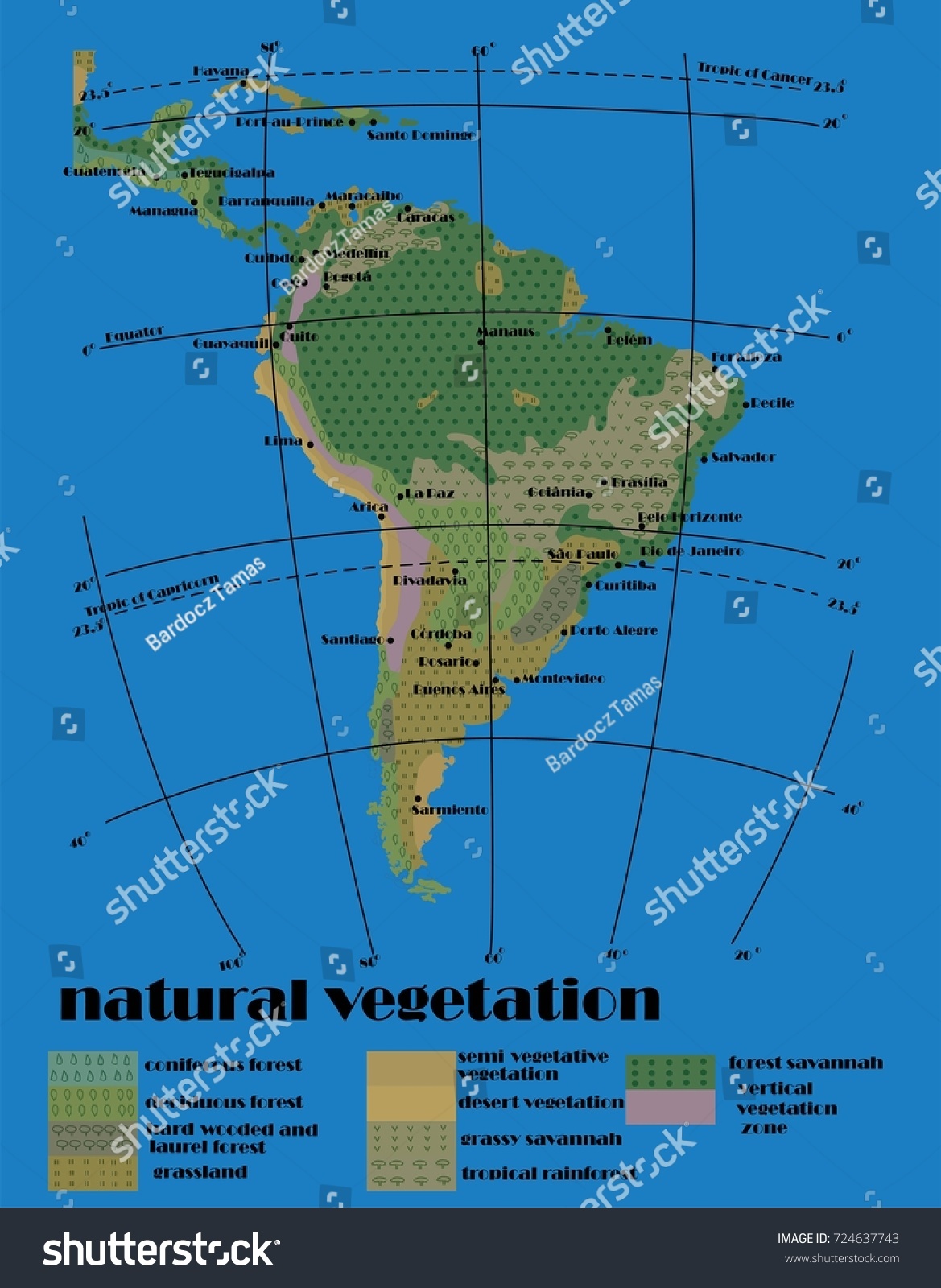
South America Natural Vegetation Stock Vector (Royalty Free) 724637743
(a) Observed Vegetation Distribution Over South America From The USGS

(a) Observed vegetation distribution over South America from the USGS ...
Map Of Vegetation In Latin America And South America

Map of Vegetation in Latin America and South America
(PDF) A Vegetation Map Of South America

(PDF) A vegetation map of South America
1968 Map Showing Vegetation In South America

1968 Map Showing Vegetation in South America
Greenhouse Management: Key Steps For Success In South America
Greenhouse Management: Key Steps for Success in South America
Vegetation Map America A VEGETATION MAP OF SOUTH AMERICA
Vegetation Map America A VEGETATION MAP OF SOUTH AMERICA
Figure 3 - Vegetation Map Of South America
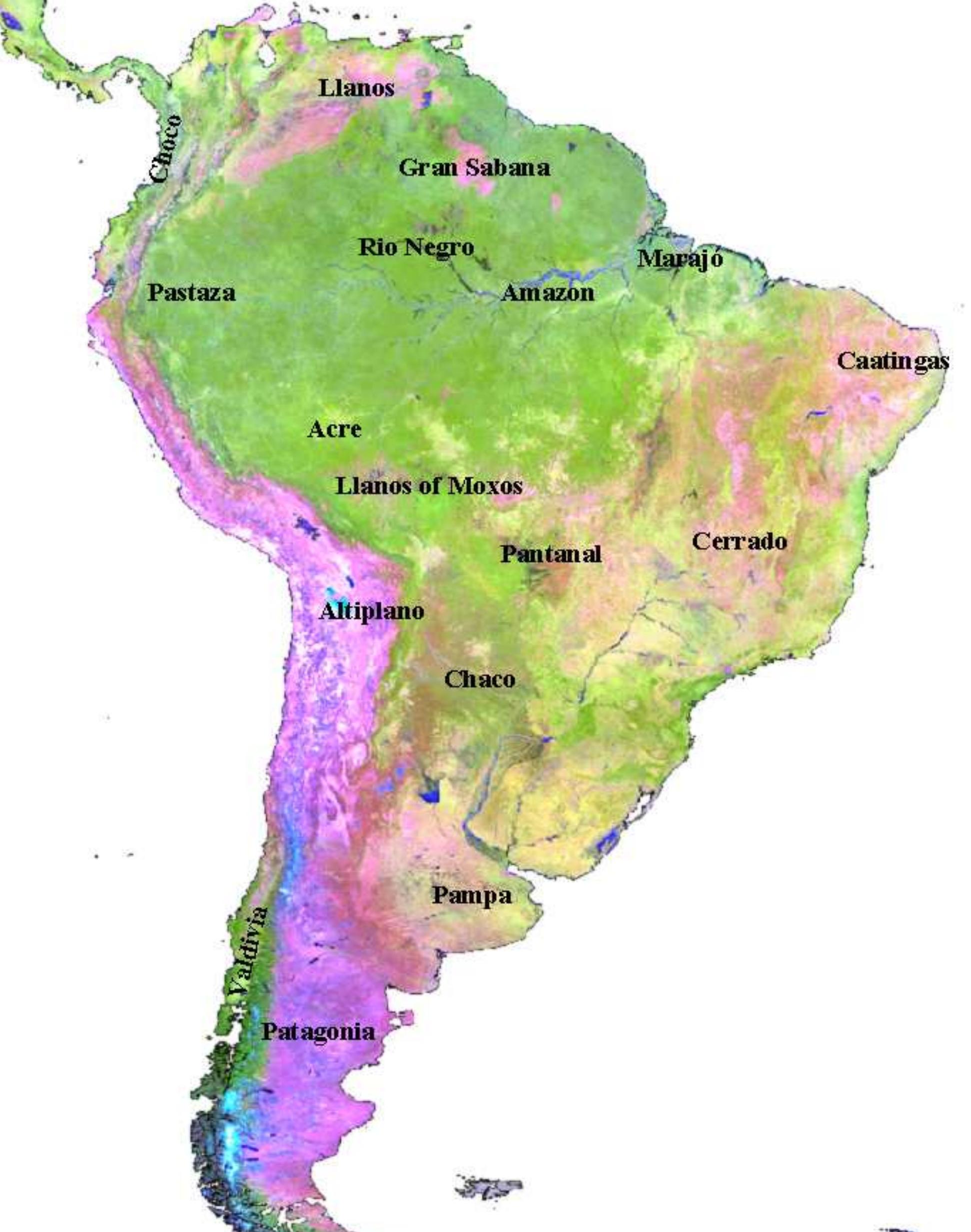
Figure 3 - Vegetation Map of South America
South America - Lakes, Rivers, Wetlands | Britannica
South America - Lakes, Rivers, Wetlands | Britannica
(PDF) A Map Of Vegetation Of South America Based On Satellite Imagery

(PDF) A Map of Vegetation of South America Based on Satellite Imagery
Vegetation Map Of South America From AVHRR 1992/1993. Available At

Vegetation map of South America from AVHRR 1992/1993. Available at ...
(a) Map Of Major Vegetation Types In Central And Northern South America

(a) Map of major vegetation types in central and northern South America ...
Figure 2 - Vegetation Map Of South America
Figure 2 - Vegetation Map of South America
1. Major Vegetation Zones Of Southern South America. | Download

1. Major vegetation zones of southern South America. | Download ...
Map Of Southern South America Showing The CWP, Main Vegetation
Map of Southern South America showing the CWP, main vegetation ...
Map Of Southern South America Showing Vegetation Zones Based On Refs

Map of southern South America showing vegetation zones based on refs ...
Tree Cover And Urban Areas Of South America
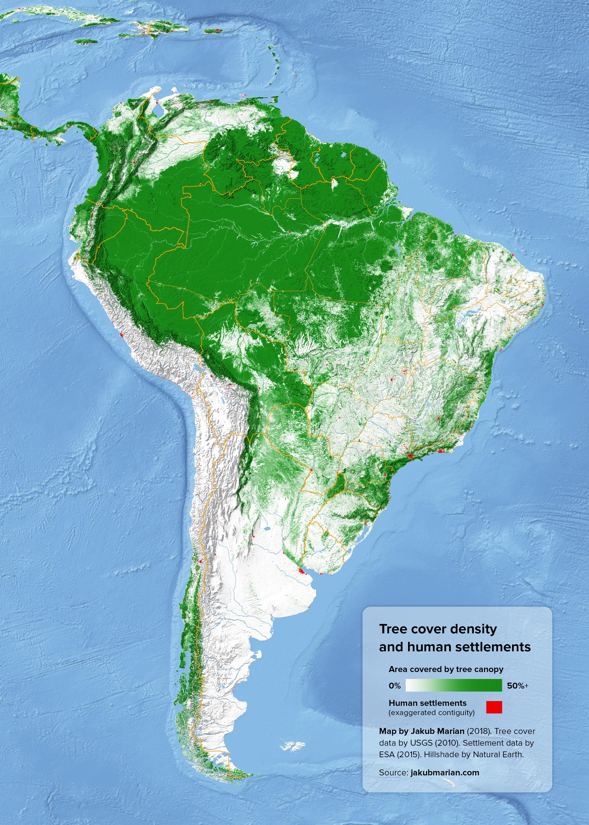
Tree cover and urban areas of South America