Exploring Australia's Mining Regions: A Detailed Black Tone Map of State Resources
This guide provides an in-depth exploration of Australia's mining regions, presented through a visually striking black tone map. You will learn about the major mineral and resource deposits across each Australian state and territory, understand the strategic significance of key mining hubs, and gain insight into how these regions drive the nation's economy. Whether you are a student, investor, or industry professional, this resource offers a clear, geographic overview of the country's vast mineral wealth.
The Importance of a Black Tone Map for Mining Regions
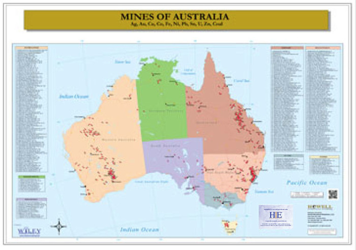
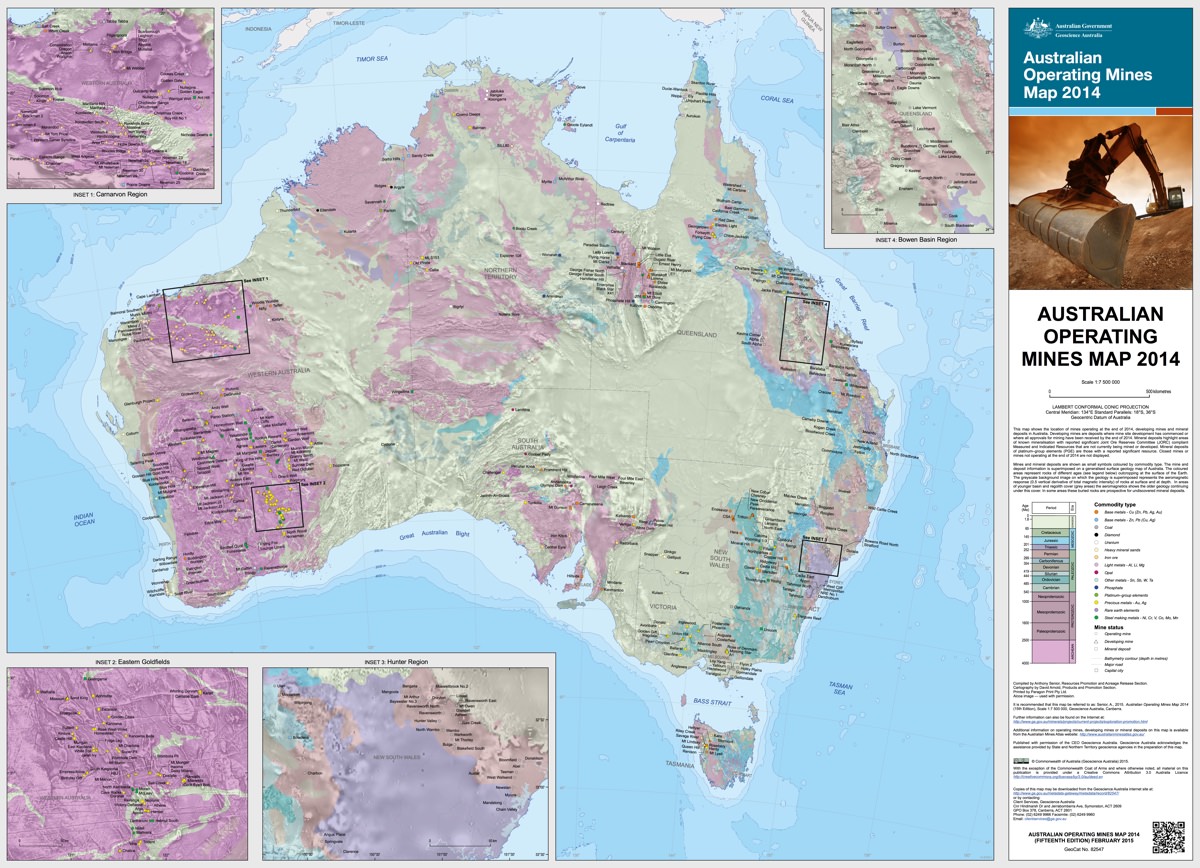
A black tone map of Australia's mining regions is more than a stylistic choice; it emphasizes contrast and clarity. By removing color distractions, the map highlights the outlines of states, major mine locations, and resource project areas. This design is particularly useful for presentations, reports, or digital displays where a high-contrast, professional appearance is needed. The black background often makes mineral symbols, state borders, and labeled resource clusters stand out, allowing viewers to quickly grasp the spatial distribution of deposits such as iron ore, gold, copper, and coal.

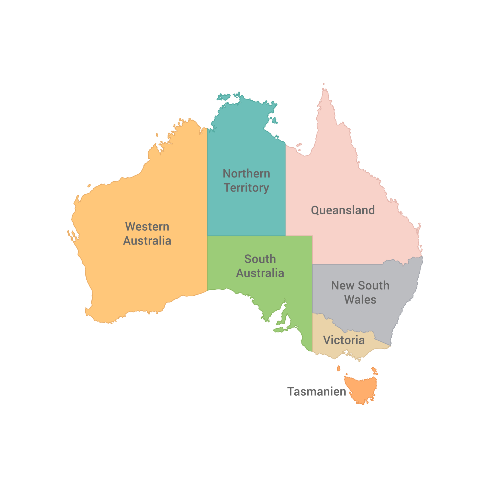
Western Australia: The Mining Powerhouse
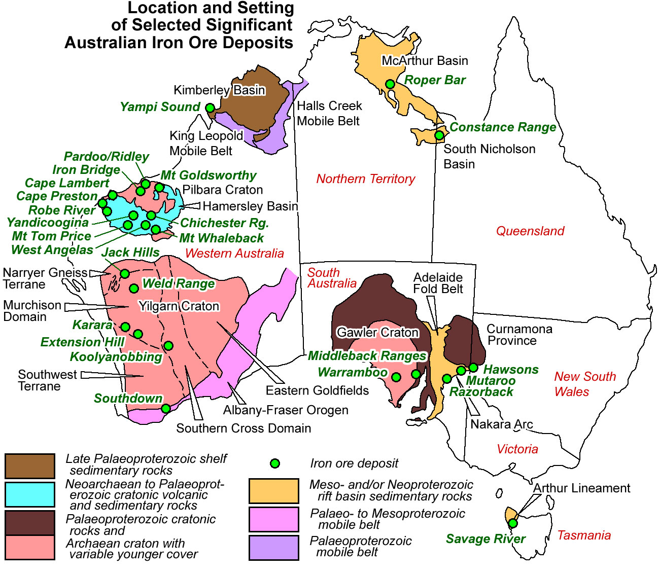
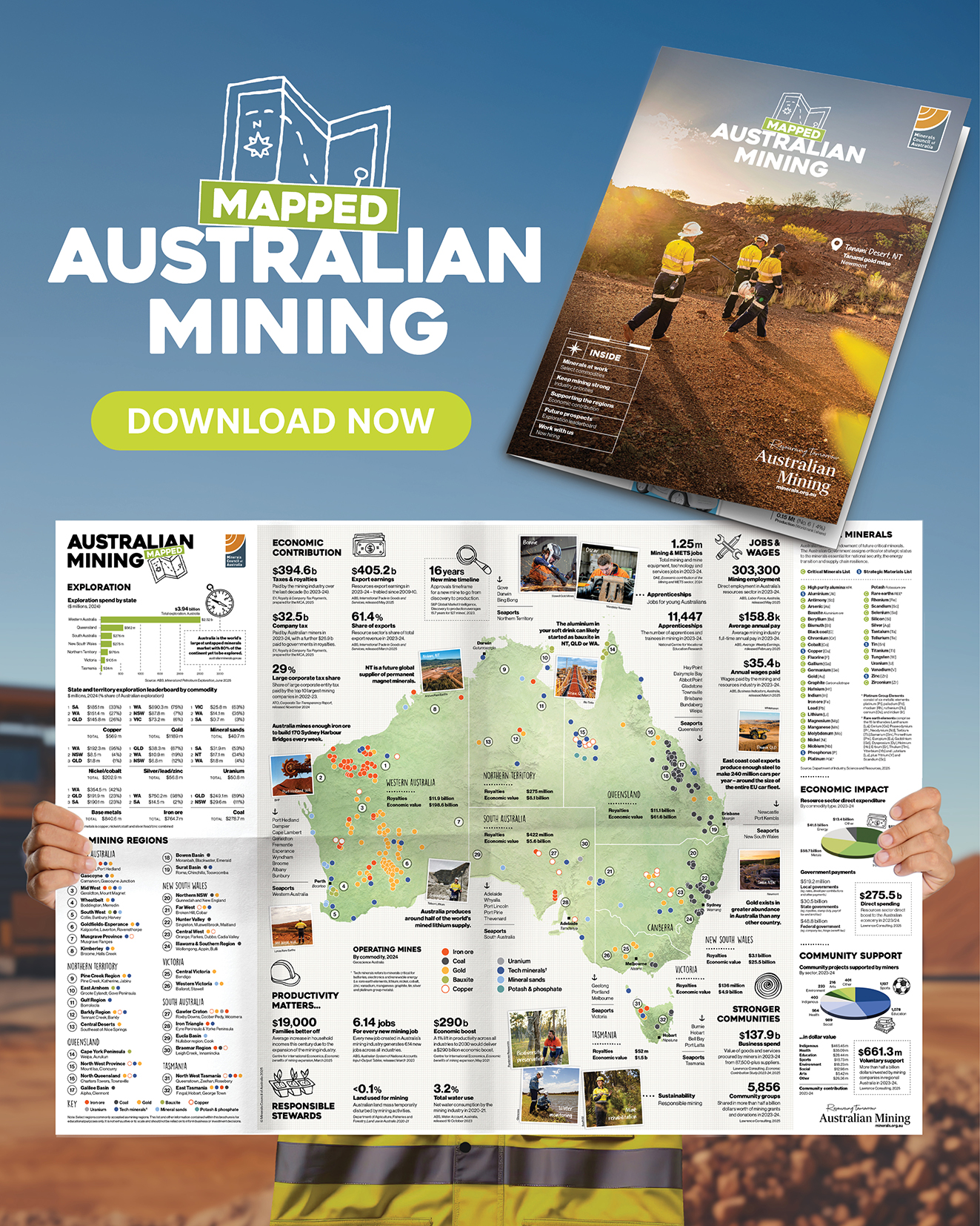
Western Australia dominates much of the mining map. The Pilbara region, shown in striking black and white on any detailed map, is the epicenter of iron ore extraction. Major mines like Mount Whaleback and Solomon Hub are connected to ports such as Port Hedland and Dampier. Goldfields regions, including Kalgoorlie and the Super Pit, also feature prominently. The state’s vastness means that mineral deposits for nickel, lithium (notably in Greenbushes), and rare earths are spread across the map, often symbolized by distinct markers along the western and central corridors.
Queensland: Coal, Copper, and Bauxite
Queensland's mining regions are heavily concentrated in the Bowen Basin for metallurgical and thermal coal, a sector that appears as dense clusters in the map’s northeast. The Mount Isa region, represented by copper and lead-zinc symbols, is another critical node. In the far north, bauxite mining around Weipa and the emerging critical minerals projects near Charters Towers are key features. A black tone map effectively delineates these zones, showing the proximity of rail lines and export terminals along the coast.
New South Wales and Victoria: Base Metals and Gold
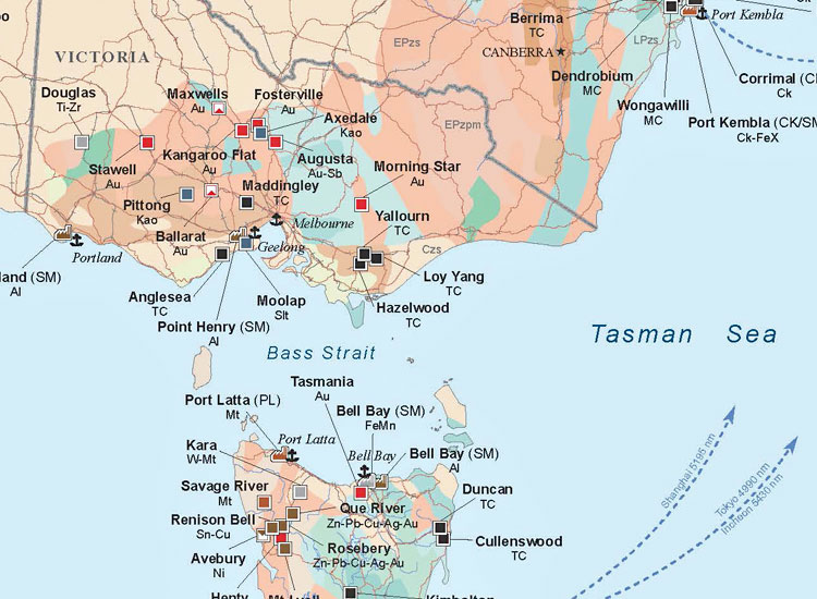
New South Wales boasts major copper and gold operations in the Lachlan Fold Belt, such as the Cadia Valley mine. The state also features significant coal mining in the Hunter Valley and Illawarra regions. Victoria’s mining footprint is smaller but historically rich, with the Bendigo and Ballarat goldfields still active. On a black tone map, these regions appear as distinct strips along the Great Dividing Range, with Victoria’s deposits concentrated in the west and central areas.
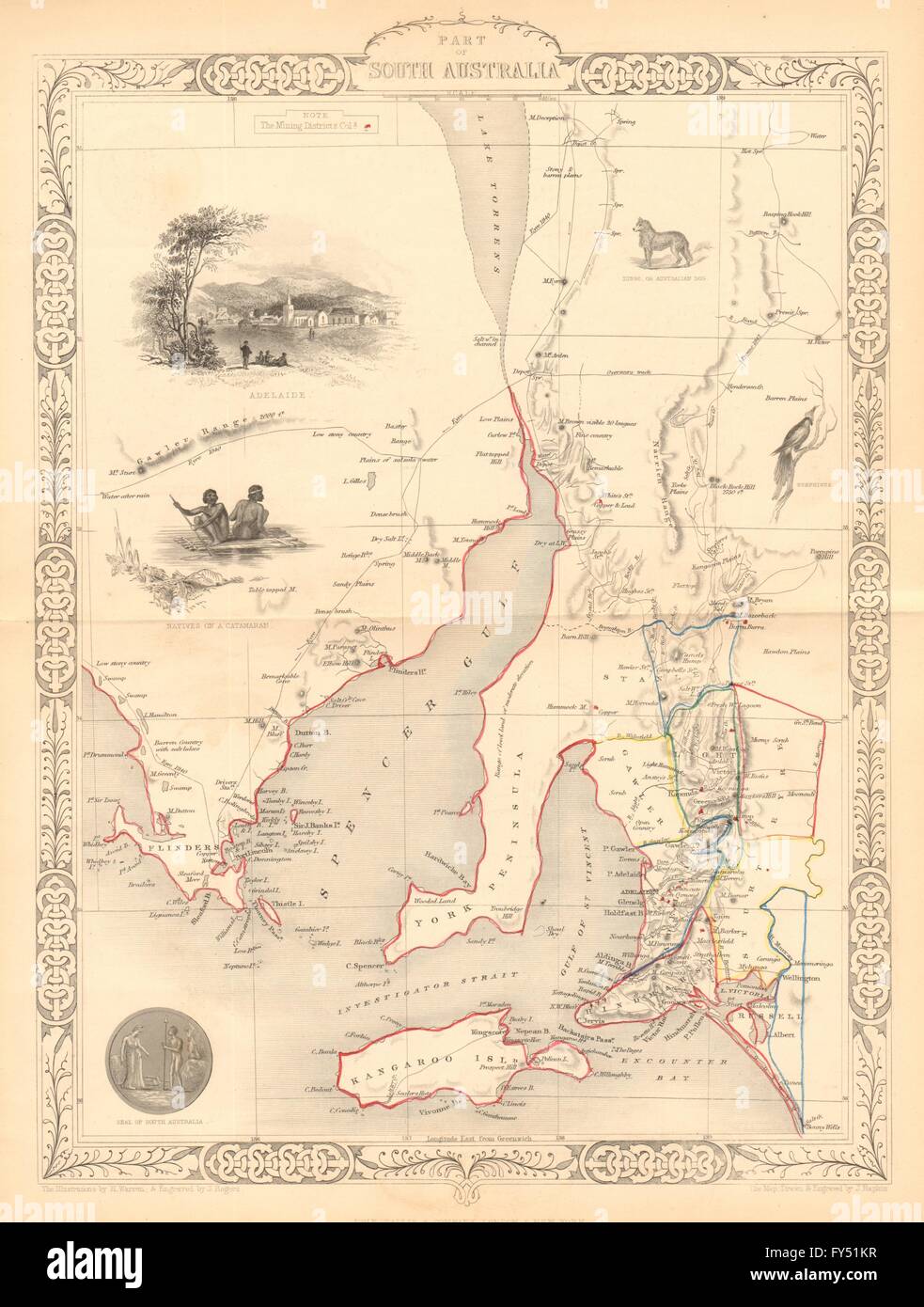
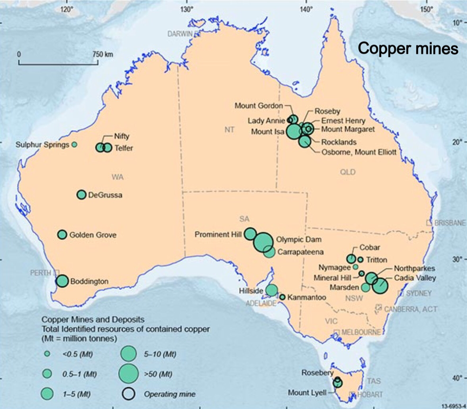
South Australia: Copper, Uranium, and Future Projects
South Australia is known for its Olympic Dam mine, one of the world’s largest deposits of copper, gold, and uranium. The state’s map also highlights the Gawler Craton, with new projects in the Far North. As shown in the example map from June 2025, South Australia’s mining regions are expanding, with numerous resource project areas marked near the Eyre Peninsula and the Musgrave Block. The black tone design enhances the readability of these remote, spread-out geological provinces.
Northern Territory and Tasmania: Emerging and Niche Resources
The Northern Territory features major manganese mines near Groote Eylandt and gold operations at the Tanami desert. The map shows a sparse but significant distribution of deposits, often in remote inland areas. Tasmania, while smaller, is rich in base metals such as copper, zinc, and lead at the Rosebery and Mount Lyell mines. A black tone map of these regions effectively illustrates how Tasmania’s mining is clustered in the island’s mountainous west, contrasting with the Northern Territory’s vast, isolated sites.
Key Commodities and Their Geographic Patterns
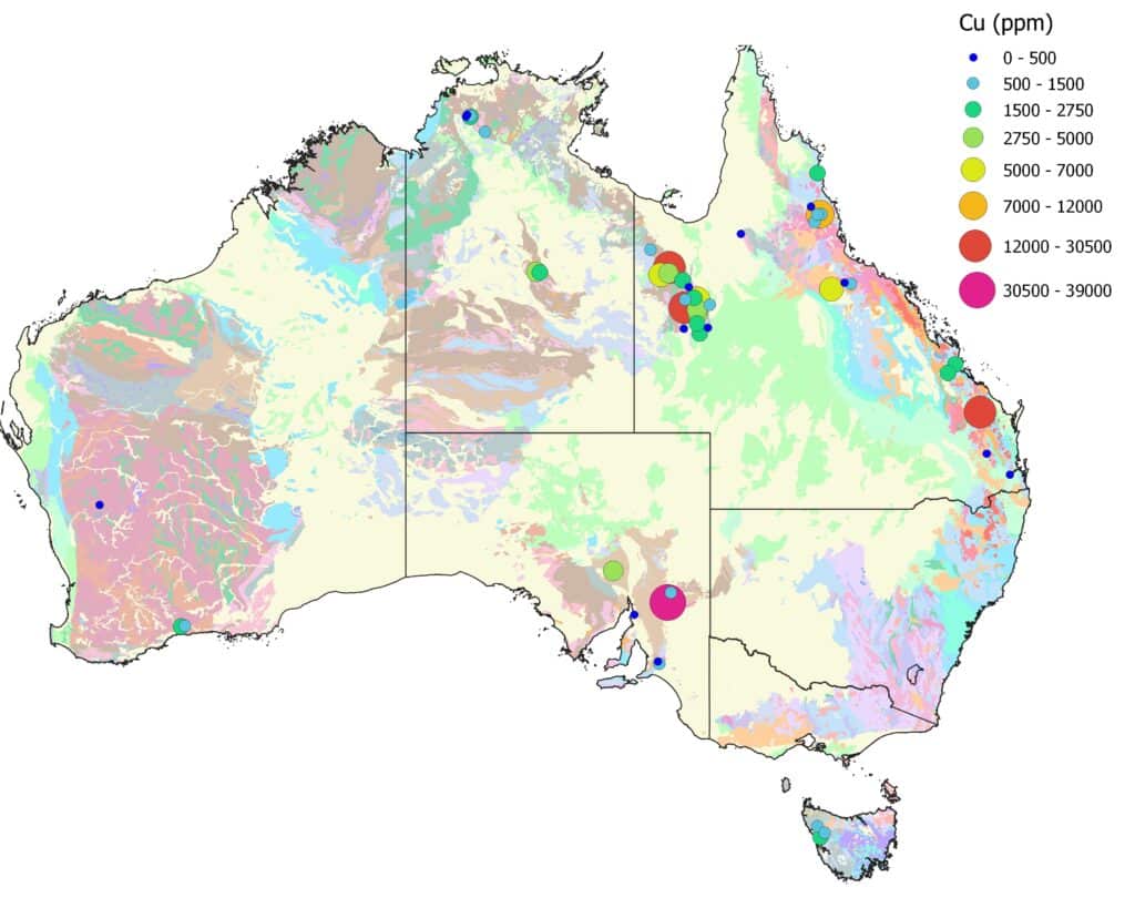
Studying a black tone map of Australian mining regions reveals clear geographic commodity patterns. Iron ore is overwhelmingly dominant in Western Australia’s northwest. Coal is split between Queensland’s Bowen Basin and New South Wales’ Hunter Valley. Gold deposits are widespread, but major clusters exist in Western Australia, Victoria, and the Northern Territory. Lithium and rare earths are increasingly appearing as symbols in Western Australia and South Australia. Copper is a common thread, stretching from Mount Isa through South Australia into New South Wales. The map’s monochrome nature makes these patterns highly legible without color-coded distractions.
Infrastructure and Logistics on the Map
Beyond mines, a comprehensive map of Australia’s mining regions in black tone often includes major transportation infrastructure. Rail lines connecting inland mines to coastal ports are visible as thin black lines. Key ports such as Port Hedland, Gladstone, and Newcastle are usually marked. The map might also show gas pipelines and major roads serving remote sites. This logistical layer is critical for understanding how resources move from extraction points to global markets, and the black tone helps separate these linear features from the blocky shapes of mining tenements.
Conclusion
Australia’s mining regions are vast, diverse, and economically vital. A black tone map offers a unique and effective way to visualize their distribution across states like Western Australia, Queensland, New South Wales, South Australia, and the Northern Territory. By focusing on contrast and clarity, such a map highlights the concentration of iron ore, coal, gold, and critical minerals, along with the infrastructure that supports them. Understanding this geographic layout is essential for anyone involved in resource strategy, investment, or environmental planning. The rich detail of these maps, from the Pilbara to the Gawler Craton, tells the story of a continent built on mineral wealth.
Mining In Australia - Rocks

Mining In Australia - Rocks
Uranium Mining In Australia - Wikipedia

Uranium mining in Australia - Wikipedia
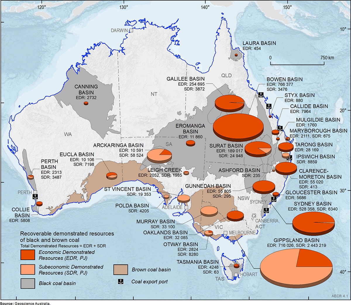
Businessmapsaustralia — Australian Coal Mines And Deposits - 2018

Businessmapsaustralia — Australian Coal Mines and Deposits - 2018
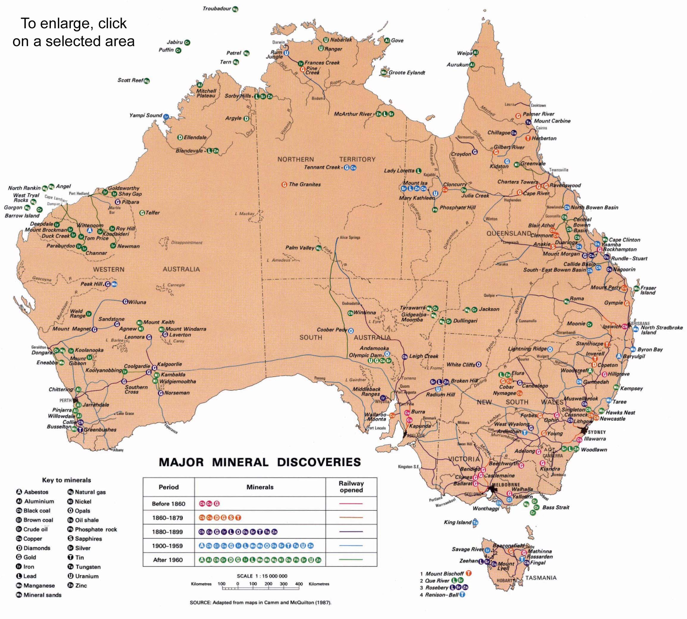
Australia On A Mining Towns Map
Australia On A Mining Towns Map
Australia On A Mining Towns Map

Australia On A Mining Towns Map
Mining Maps, Buy Mining And Resources Maps - Mapworld
Mining Maps, Buy Mining and Resources Maps - Mapworld
Metals To Medals - Mining Magazine Australia
Metals to medals - Mining Magazine Australia
Jewels Mining Map Of Australia Map Of Diamond Creek Mine In Victoria

Jewels Mining Map Of Australia Map Of Diamond Creek Mine In Victoria
Iron Mines In Australia Map At Danita Foster Blog
Iron Mines In Australia Map at Danita Foster blog
Iron Mines In Australia Map At Danita Foster Blog

Iron Mines In Australia Map at Danita Foster blog
South Australia Mines Map
South Australia Mines Map
Iron Mines In Australia Map At Danita Foster Blog
Iron Mines In Australia Map at Danita Foster blog
Not A Mega-Mine: Coal Mines In Australia | Bravus Mining & Resources

Not a Mega-Mine: Coal Mines in Australia | Bravus Mining & Resources
South Australia Mines Map Our Assets Evolution Mining

South Australia Mines Map Our Assets Evolution Mining
Jewels Mining Map Of Australia Map Of Diamond Creek Mine In Victoria

Jewels Mining Map Of Australia Map Of Diamond Creek Mine In Victoria
Mining Maps, Buy Mining And Resources Maps - Mapworld

Mining Maps, Buy Mining and Resources Maps - Mapworld
Australia On A Mining Towns Map
Australia On A Mining Towns Map
Minerals And Energies In Australia Map - Australia • Mappery
Minerals and Energies in Australia Map - Australia • mappery
Amazing Australia: A Hub Of Mining Opportunities Australia, Known For

Amazing Australia: A Hub of Mining Opportunities Australia, known for ...
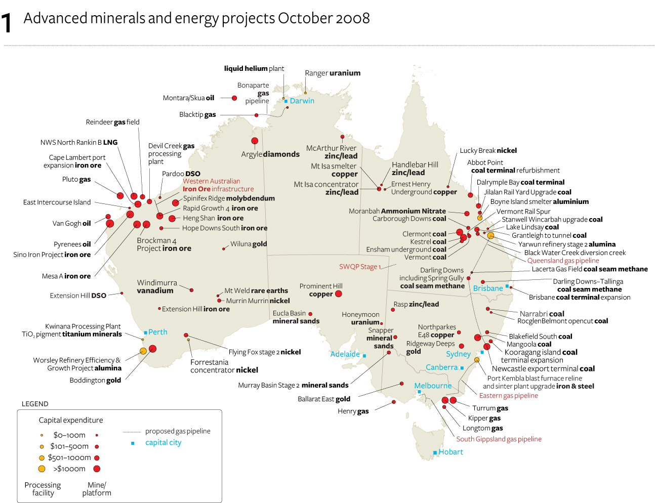
Mining In Australia: Where It Stands Halfway Through 2015 - Cannon
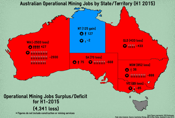
Mining in Australia: where it stands halfway through 2015 - Cannon ...
Figure 1 From Surface Coal Mining Methods In Australia | Semantic Scholar

Figure 1 from Surface Coal Mining Methods in Australia | Semantic Scholar
John T. Boyd Company - Mining And Geological Consultants – Virtual Hub

John T. Boyd Company - Mining and Geological Consultants – Virtual Hub
Jewels Mining Map Of Australia Map Of Diamond Creek Mine In Victoria
Jewels Mining Map Of Australia Map Of Diamond Creek Mine In Victoria
Jewels Mining Map Of Australia Map Of Diamond Creek Mine In Victoria
Jewels Mining Map Of Australia Map Of Diamond Creek Mine In Victoria
Gold - Minerals Council Of Australia
Gold - Minerals Council of Australia
Mining Industry Of Australia - Part 1

Mining Industry of Australia - Part 1
Mining In Australia - Geography

Mining in Australia - Geography
Mining In Australia: A Balanced And Informed Conversation Needed

Mining in Australia: A balanced and informed conversation needed ...
Mining Tenements Explained - Miners Data

Mining Tenements Explained - Miners Data
Geoscience Australia On LinkedIn: #maps #mining #minerals #deposits

Geoscience Australia on LinkedIn: #maps #mining #minerals #deposits
Australia On A Mining Towns Map

Australia On A Mining Towns Map
Australia Map Vector With States In Illustrator, SVG, JPG,, 47% OFF
Australia Map Vector With States In Illustrator, SVG, JPG,, 47% OFF
South Australia Mines Map
South Australia Mines Map